Even sites once protected by Congress, including a butterfly refuge and a historic church, are slated for fencing funded by the “one big beautiful bill”—while the river itself is transformed by a floating barrier.
A pioneering asylum lawyer in El Paso leaves a legacy of lives saved, an immigration judge fired by the Trump administration asks, 'What's next?' at the border, and The Border Chronicle's, Caroline Tracey, has a new book out!
Inside Trump’s Plan to Finish Walling Off the Rio Grande Valley
Even sites once protected by Congress, including a butterfly refuge and a historic church, are slated for fencing funded by the “one big beautiful bill”—while the river itself is transformed by a floating barrier.
Nayda Alvarez looks at the “No Border Wall” that she painted on her roof 7 years ago near Rio Grande City, Texas on March 4, 2026. (Photo credit: Michael Gonzalez)
About 10 miles upstream from the mouth of the Rio Grande, along a quiet bend of the river near a historic Civil War battle site, Mexican fishermen in overalls casting their nets into the water are a familiar sight. Brown pelicans sometimes follow fishing boats, hoping to catch a meal. The sound of water splashing along the riverbank from the wake of a boat is oddly comforting.
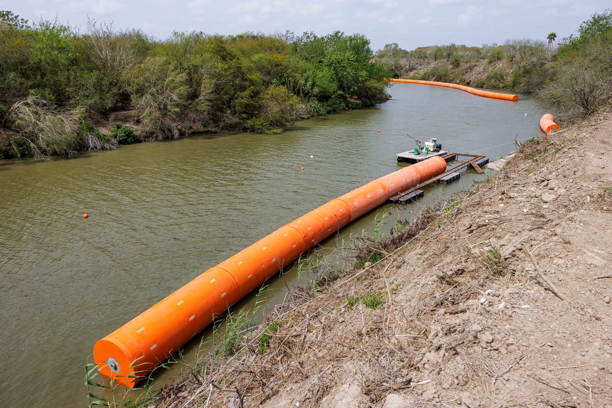
But these days, as far as the eye can see along the natural border, small white buoys are sporadically placed marking a “restricted area” and declaring the river as property of the federal Department of Defense, part of President Donald Trump’s ongoing efforts to militarize the region. Small signs are wrapped around the buoys here, east of the border city of Brownsville. These warning signs are only one small indicator of the vast change that will transform the river.
More than a year into Trump’s second term, barrier construction has been steadily proceeding in the Rio Grande Valley, both on land and in the river. Last year, Congress appropriated nearly $47 billion for border barrier construction, encompassing both 30-foot-tall steel fencing and river barriers made up of larger orange buoys to deter crossers, along with surveillance technology. This is a major investment in finishing the valley’s barrier—which spans about 150 miles by car and 275 river miles from Cameron County upriver through Hidalgo and Starr counties—and encompasses disconnected stretches of both federal- and state-built border fencing.
Historically, it’s been difficult for wall-building presidents to conquer this region, thanks to its varying terrain and its riverfront landowners, who often have complicated claims dating back centuries. But the Trump administration is taking them on with its plans to add about 90 miles of new and replacement wall. This would seal off the region from the Brownsville Ship Channel all the way up to Falcon Dam, completing the job started by former presidents George W. Bush and Barack Obama.
From trucks loaded up with the orange buoys—measuring 15 feet long and four to five feet wide—driving through the pothole-ridden streets of Southmost in Brownsville to shipments of steel border wall bollard panels hauled down Valley highways, the rapid spending of these taxpayer dollars is on display all around the region.
“For months, I’ve been documenting the Department of Homeland Security and their masked contractors installing buoys in the Rio Grande,” Bekah Hinojosa, cofounder of the South Texas Environmental Justice Network (SOTXEJN), told TheTexas Observer and The Border Chronicle. “The Department of Homeland Security is not being clear intentionally about what their plans are, what they’re deploying in the region, and so it’s up to us in the community to track and document and report on it. This is how we fight back.”
A staging ground where the orange buoys are received by the truckload is situated a stone’s throw from the Veterans International Bridge in Brownsville. On March 6 around noon, a mix of masked and unmasked construction workers unloaded the buoys. In the river, fragmented sections floated on the U.S. side. This section is set to receive 17 miles of buoys at a cost of $96 million. According to a Customs and Border Protection (CBP) online “Smart Wall Map,” the agency plans to install over 500 miles of buoys in the Rio Grande, from the Gulf upriver well beyond the valley and even past Eagle Pass.
Standing amid the brush on the riverbank that Friday, as a boat driven by a construction worker passed, Carrizo/Comecrudo Tribe member and SOTXEJN cofounder Christopher Basaldú stared quietly at the bright-orange objects floating in the river. He worried about the buoys further polluting the river—which supplies water to over 1.5 million residents, as well as to wildlife—and about the broader moral issues.
“What the barrier buoys are doing, just like the wall, is that it’s saying that all the human beings that live on the other side of the buoys and the wall are disposable, or their lives are meaningless,” Basaldú said. “It’s showing that the government is willing to literally waste billions upon billions of dollars to make these useless walls instead of taking that exact same money and making sure that everybody has housing or clean water and food and education.”
As Basaldú spoke, a construction worker pulled a neck gaiter up to cover his face and approached us. The worker declared the riverfront area a federal project and repeatedly demanded my press credentials, which he then photographed.
With the help of community members, Bekah Hinojosa took point on drafting a letter opposing the installation of buoys in the river and detailing how they violate human rights and have ecologically damaging effects. After approaching Cameron County judge Eddie Treviño at a forum in February to hand-deliver the letter, Hinojosa asked him to take a public stance against the buoys. A week and a half later, Treviño introduced a symbolic resolution, and the county commission voted unanimously against the buoys.
As for the border wall, much of Cameron County already had fencing before Trump’s second term, but the CBP map shows plans for significant additions and replacements. At the southern end of UT-Rio Grande Valley’s Brownsville campus, the map shows a new wall—which is typically 30 feet tall under both Trump administrations—replacing a shorter green mesh fence, which had been a significant compromise in the first era of valley wall construction. The wall is also projected to skirt just south of a golf resort that was previously spared.
A section of a 17-mile long stretch of buoy barriers floats downriver from the Veterans International Bridge in Brownsville, Texas on March 6, 2026. (Photo credit: Michael Gonzalez)
Upriver, much of the planned border wall construction will fill gaps in between existing sections in Hidalgo County (in addition to new buoys). In 2019, Congress passed a bill adding protections to exempt certain sites from border wall construction in Hidalgo, including the historic La Lomita Chapel, Santa Ana Wildlife Refuge, National Butterfly Center, and Bentsen-Rio Grande Valley State Park. Seven years later, these sites face renewed challenges, because last year’s One Big Beautiful Bill did not maintain those protections and because the CBP map projects border barrier construction running through each site. Laredo representative Henry Cuellar has previously said he believes the protections should still apply; he did not provide comment by press time for this article.
In most of Hidalgo County, home to McAllen, the border wall is built (dating back to the early Obama administration and continuing in Trump 1.0) by converting an existing earthen levee, sloped and simple to drive or walk over, into a sheer concrete wall topped with steel bollards (in Cameron County, the steel fencing has been built adjacent to the levee, while in Starr there is no levee to convert or build beside). This means the wall takes a meandering path through important sites; for example, the levee runs just 100 feet north of the historic La Lomita Chapel and bisects the butterfly center. Under Trump, the standard wall design has also included a 150-foot clear-cut “enforcement zone” next to the barrier.
CBP spokesperson John Mennell said the online map, which shows the fence running through the protected sites, “accurately depicts current wall planning efforts,” adding, “All recently awarded projects and future contract awards are funded with [One Big Beautiful Bill Act] OBBBA funds.” Mennell said the contract for the project that includes the protected sites—labeled “Rio Grande Valley 4”—was awarded on March 18. Regarding La Lomita specifically, he said that access “will not be impeded,” and access gates will be installed “as needed.”
Siblings Fred and Lisa Cavazos are no strangers to fighting border wall construction. The Cavazos’ land is located between the chapel and the butterfly center. Their family home is north of the levee; south of it, they have riverfront acreage where they keep cattle and rent out lots. They’re a rare case in the area: even though they received no congressional protection during Trump’s first term, they managed to fend off the wall through legal maneuvering and gaining press attention.
On a windy March afternoon at their family property, Fred and his cousin, Rey Anzaldúa, recalled working the land owned by their grandmother when they were teenagers. Fred’s father was a farmer, so they would help with these tasks in addition to their grandmother’s improvement projects. “This is my interest in this property because I spent most of my teenage years here,” said Anzaldúa, who lives in nearby Edinburg. “Even if I don’t own any of the property, I consider this my home.”
Since the beginning of Trump’s efforts to build on their family land, Anzaldúa told Fred that he would help only if they never backed down and fought until the end. Anzaldúa had experience opposing the government over border wall construction in El Granjeno, the small town just down the road where he was born, which eventually saw the levee at its southern boundary converted. The wall in this area was funded under the George W. Bush administration and built under Obama.
At 81 years old, Anzaldúa is once again ready and willing to help Fred fight to prevent the border wall from infringing upon the Cavazos land. The future of their fight is uncertain as construction progresses daily on properties much too close for comfort.
But one thing should slow Trump down. After years of the family’s maneuvering aimed at delay, the Biden administration returned the strip of the Cavazos’ land that Trump had condemned for wall construction. The family hasn’t received any notice yet of new eminent domain proceedings and only discovered that wall construction would once again encroach on their property from recent news coverage. The spokesperson for CBP said that the agency “engages with landowners and relevant stakeholders” and noted that there are access gates in the existing wall near the Cavazos’ property.
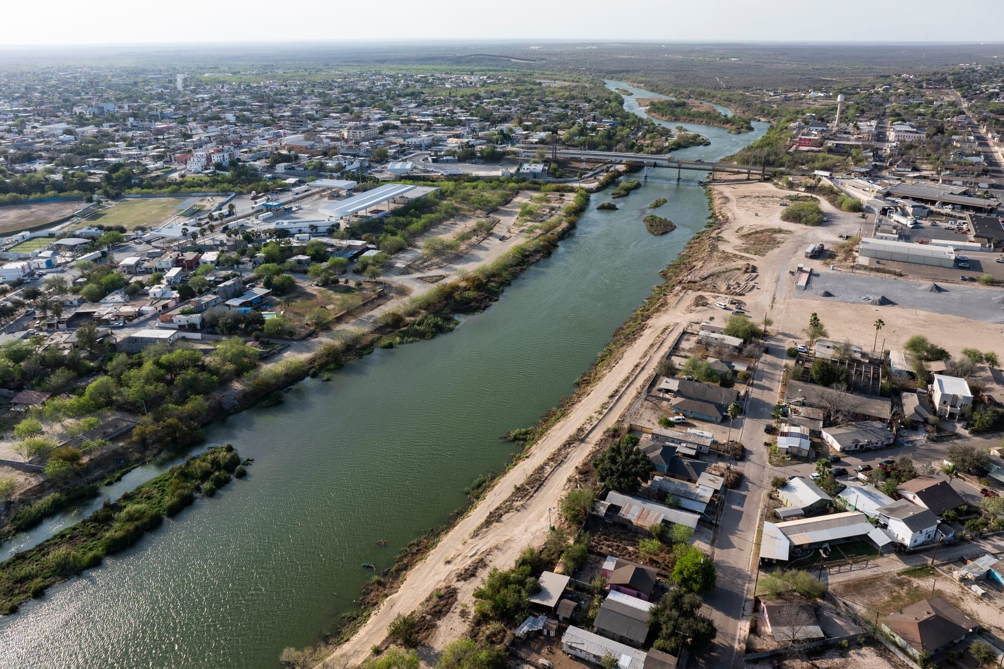
An aerial view of the De La Cruz Colonia, right, where border wall construction is planned along the Rio Grande in Roma, Texas, on March 4, 2026. (Photo credit: Michael Gonzalez)
In flood-prone Starr County, the most rural of the valley’s four border counties, wall construction has been stymied for two decades. Without a levee, there’s no clear path for the barrier to follow, and planners must decide between routing it through residential areas or through floodplains, which can worsen local flooding or threaten the structure itself. During his first administration, Trump managed to build on only a couple of short stretches of federal refuge toward the county’s western end.
But now, following some state-level wall construction in the county by Governor Greg Abbott, the buildout is moving rapidly.
According to the CBP planning map, projects are contracted out or under construction to wall off Starr from end to end. The U.S. Fish and Wildlife Service manages over 100 fragmented tracts of land across the Lower Rio Grande Valley National Wildlife Refuge, and several of these are sprinkled across Starr County and have recently been partially stripped as site preparations are made.
The CBP spokesperson said that when building in a floodplain, the agency “conducts a hydraulics analysis … to ensure construction does not alter the natural flow of the Rio Grande River or increase significantly floodwaters into Mexico.”
Much like Fred Cavazos and Rey Anzaldúa, Nayda Alvarez is once again preparing to fight with all her strength to prevent her family land from being taken for border wall construction. Looking up at the roof from the back of her home, Alvarez takes note of the fading white letters she painted on the shingles reading “No Border Wall.” When she first painted the letters seven years ago, Alvarez hoped to grab the attention of any helicopter pilots flying above her home so they would know her stance on the controversial issue of border wall construction. “I should repaint it, but first I need to replace the roof,” Alvarez said while staring pensively at her home in Starr County, located between Roma and Rio Grande City and about 250 feet from the Rio Grande.
During Trump’s first term, she faced the prospect of border wall construction tearing through her peaceful property, with her home potentially in the path. Alvarez was represented by the Texas Civil Rights Project and the American Civil Liberties Union of Texas, which also represented the Cavazos family, as she navigated land survey requests, the possibility of eminent domain, and courtroom hearings. Alvarez recalled the judge looking over a map and stating that there was nothing of value on her property. Alvarez grew up here—and her dad lives in a separate house nearby—making a lifetime of memories in the process.
Ultimately, the case was dismissed, but Alvarez remained skeptical that her family land would be spared from the wall forever. Nearly three years ago, under then President Biden, the administration announced 20 miles of border wall to be built in Starr County using money appropriated under Trump—though not including her home. Alvarez, a Democrat, felt betrayed.
“It’s like déjà vu, but this time people aren’t interested in fighting the wall anymore like they were before,” Alvarez said.
Alvarez has been teaching for 28 years, and last year she became eligible for retirement. Despite wanting to retire, Alvarez is holding on to her job out of fear that she might be forced to leave her lifelong home and take on a mortgage elsewhere.
Looking at the current CBP map, it’s hard to tell exactly where the wall will run in relation to her house. Alvarez recently received a letter asking landowners for permission to survey their property, leading her to believe that border wall construction will soon reach her doorstep.
The wall in Alvarez’s area will be built “closer to the riverfront than the houses,” said the CBP spokesperson.
“A lot of people are fine with it,” Alvarez said. “I tell them, ‘Yeah, because it’s not going to affect you. You’re not the one that’s going to lose access to the river.’”
Upriver in Roma, a border town of about 10,000, a historic central plaza sits atop a river bluff. The CBP map shows the wall running roughly along the narrow strip of land between the water and the bluff, but Roma’s city manager said the city was unaware of any plans to build the typical 30-foot wall through this area. The CBP spokesperson said that “in most locations, [the agency] is constructing 30-foot-tall border wall panels; however, in this location, the design has not been finalized, and CBP will work with the contractor to determine the wall height.”
Just downstream from the plaza is the international bridge, then a colonia called De La Cruz, and then a short section of state-built border wall.
José Noe Loera, a truck driver, grew up in De La Cruz and lives at his parents’ home beside the Rio Grande while he saves to buy a house for his wife and three kids. His parents, who have lived in the neighborhood for over 30 years, built a home around 15 to 16 years ago. It sits atop a foundation more than two feet tall in case another flood sweeps through the area, like the last major event in 2010.
Looking toward the state-built border wall visible from their backyard, Loera was surprised to learn that a CBP map shows a 34.1-mile section of border wall marked as under contract that would run through their backyard. From Loera’s parents’ backyard, the riverbank is less than 200 feet away. From other homes in their neighborhood, backyards are less than 100 feet away. Without exact plans from CBP, the possibility looms that homes will be acquired through eminent domain and demolished.
Sitting in the carport next to their home as his kids laughed and played around them, Loera expressed the sadness of such a reality. “Where are we going to go?” Loera said. “First of all, we don’t got nowhere to go. It’s going to be sad, leaving all these memories here where we grew up.”
The agency spokesperson said the wall here “will be constructed adjacent to the patrol road along the river” and that “CBP does not anticipate needing to acquire the land where the houses are situated.”
Meanwhile, toward the far western edge of Starr County, a 2.6-acre tract of land just shy of the riverbank constitutes a global birding destination known as the Salineño Wildlife Preserve, owned by the Valley Land Fund.
Just upriver from the birding destination, a section of the border wall is listed as under construction, according to the CBP map. Avid birdwatcher Bob Bowman, who has spent the last three years volunteering at the wildlife preserve during the November–March birdwatching season, said that every day, bulldozers, trucks, and general construction noise can be heard.
On the CBP map, the planned wall runs just north of the preserve. But Bowman expressed concerns that once construction starts closer to the property, they will likely have to close for at least one season because of the noise and the “unbelievable amount of destruction” it will cause. It remains uncertain whether there will be a gate providing access to the wildlife preserve. The CBP spokesperson said that “access gates may be incorporated to provide access to land south of the wall, if required.”
Bowman views the wall itself as a smaller issue compared to the destruction of the landscape around the proposed construction site. The barren enforcement zone surrounding sections of the border wall is a man-made “wasteland,” he said.
“Will it affect the birds? Of course it will affect the birds,” Bowman said. “It’s massive amounts of habitat that get wiped out by this thing.”
Support independent journalism from the U.S.-Mexico border. Become a paid subscriber today for just $6 a month or $59 a year. We can't do this without you!
“We love Big Bend the way it is. It does not need to change. We do not feel any danger, and we don’t want it to look like other places. And nothing makes a person who lives out here more mad than the idea of looking at a damn fence.”
Environmental advocates and residents say the long-proposed refinery threatens air quality and public health in a region already ringed by heavy industry.
Walking from a blasted mountain top--a planned site for new border wall construction--to a makeshift military camp along the border in a remote part of southern Arizona led to a tense yet revelatory moment.