How to Use This Map
How to Use This Map
Wall Watch is an interactive, continuously updated mapping project documenting physical border barriers, surveillance infrastructure, and ongoing border barrier construction along the U.S.–Mexico border. The map brings together publicly available information from government records, satellite imagery, field observations, and verified community reports to help residents, journalists, researchers, policymakers, and environmental advocates to monitor where new barriers are being built and to understand their impacts on border communities, public lands, wildlife habitat, and migration.
This page functions as a user guide for understanding and using the Wall Watch map. For information about how we created and maintain the map, including a list of the data sources used for the map layers, see the Our Methodology page. For information about submitting a report for inclusion on the map, see the How to Submit a Report / Privacy Policy page.
Navigating the Map
You can move around the map just like most online maps.
- Click and drag to move the map.
- Use your mouse wheel or the + and – buttons to zoom in and out.
- Turn individual layers on or off using the Map Layers panel on the left side of the map.
- Expand each category by clicking its arrow to display the individual layers inside.
Each layer can be displayed independently or together with any combination of other layers.

Understanding the Map Layers
Border Barriers
This category displays physical barriers like walls, vehicle barriers, buoy barriers, and more. Features are organized into two layers:
Current Barrier Projects
Displays border barrier projects that are currently planned, under construction, or otherwise active.
Existing Border Barrier
Displays border barriers that have already been constructed along the border.
Barrier Types
Below the Border Barriers category is a section titled Barrier Types. These options do not represent separate datasets. Instead, they filter the Current Barrier Projects layer according to the type of barrier being selected. When we launch the full Existing Border Barrier layer that identifies each segment individually, you will be able to use the Barrier Types section to filter the Existing Border Barrier layer as well. Available barrier types include:
- Border Wall: Steel Bollard
- Vehicle Barrier
- Buoy Barrier
For example, enabling Border Wall: Steel Bollard will display only the Current Barrier Projects involving steel bollard border wall.
Barrier Construction Activity
This category documents observations of ongoing construction and preparation activities associated with border barriers, largely compiled from community reports. The layers include:
- New Construction — Active construction of new border barriers not otherwise included in the Current Barrier Projects dataset.
- Staging Areas — Locations where construction materials, equipment, or personnel are being assembled.
- Surveying — Areas where survey crews have been observed conducting preliminary work.
- Vegetation Clearance — Locations where vegetation has been removed in preparation for construction or access. This category also includes land grading.
- Enforcement Roads — Areas where new enforcement and access roads have been created.
- Environmental Impacts — Evidence of environmental impacts other than vegetation clearance and land grading, such as materials dumping, erosion and run off, light pollution, waterway obstructions, etc.
- Other — Construction-related activities that do not fit into the categories above.
Surveillance Technology
This category displays surveillance technologies deployed along the border. Layers include:
- Surveillance Towers — Fixed surveillance towers operated by U.S. Customs and Border Protection (CBP).
- Aerostats (TARS, TAS, TMSS) — Tethered surveillance balloons equipped with radar and/or optical sensors. Includes aerostats that are part of U.S. Customs and Border Protection’s Tethered Aerostat Radar System (TARS), Tactical Aerostat System (TAS), and Tactical Maritime Surveillance System (TMSS).
- ALPRs — Checkpoint/LPOE — Automatic License Plate Reader (ALPR) systems located at U.S. Border Patrol checkpoints and Land Ports of Entry (LPOEs) operated by U.S. Customs and Border Protection (CBP)/U.S. Border Patrol (USBP) or the Drug Enforcement Administration (DEA).
- ALPRs — Covert — Covert or concealed Automatic License Plate Reader (ALPR) systems operated by U.S. Customs and Border Protection (CBP)/U.S. Border Patrol (USBP) or the Drug Enforcement Administration (DEA).
- Facial Recognition Tech — Locations where facial recognition technologies are deployed by U.S. Customs and Border Protection (CBP).
Other Infrastructure
This category displays other major components of U.S. border enforcement infrastructure. Layers include:
- USBP Sectors — U.S. Border Patrol (USBP) sectors.
- USBP Stations — U.S. Border Patrol (USBP) station locations.
- USBP Checkpoints — Interior immigration checkpoints operated by the U.S. Border Patrol (USBP).
- Land Ports of Entry — Official U.S. land ports of entry along the border with Mexico.
Feature Counts
A number appears next to every category and every individual layer.
These numbers indicate the number of features currently contained within that layer. For category headings, the number represents the total number of features contained in all layers within that category.
As the Wall Watch database grows, these numbers will automatically update to reflect newly added information.

Viewing Feature Information
Clicking on any feature displayed on the map opens a pop-up containing additional information.
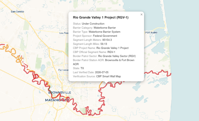
The amount of information available varies depending on the feature and the data currently available. We are constantly working to compile and refine this information, and if you have information missing from this map, please let us know by emailing us at wallwatch@theborderchronicle.com. Thank you!

Tips for Exploring the Map
- Turn on only the layers you are interested in to reduce visual clutter.
- Zoom in for the best viewing experience, especially in areas with many overlapping features.
- Combine multiple layers to better understand how construction activity relates to existing infrastructure.
- Use the Barrier Types filters to compare different forms of physical border barriers.
- Click individual features to explore detailed information and supporting documentation.

Version en Español
Cómo usar este mapa
Wall Watch es un proyecto interactivo de mapeo, actualizado continuamente, que documenta las barreras físicas fronterizas, la infraestructura de vigilancia y la construcción en curso de barreras a lo largo de la frontera entre Estados Unidos y México.
El mapa reúne información disponible públicamente proveniente de registros gubernamentales, imágenes satelitales, observaciones de campo y reportes comunitarios verificados para ayudar a residentes, periodistas, investigadores, personas responsables de formular políticas públicas y personas defensoras del medio ambiente a monitorear dónde se están construyendo nuevas barreras y comprender sus impactos en las comunidades fronterizas, las tierras públicas, los hábitats de vida silvestre y la migración.
Esta página funciona como una guía para comprender y utilizar el mapa de Wall Watch. Para obtener información sobre cómo creamos y mantenemos el mapa, incluida la lista de las fuentes de datos utilizadas para las distintas capas, consulte la página Nuestra metodología. Para obtener información sobre cómo enviar un reporte para su inclusión en el mapa, consulte la página Cómo enviar un reporte / Política de privacidad.
Navegación del mapa
Puede desplazarse por el mapa igual que en la mayoría de los mapas en línea.
· Haga clic y arrastre para mover el mapa.
· Utilice la rueda del ratón o los botones + y − para acercar o alejar la vista.
· Active o desactive las capas individuales mediante el panel Capas del mapa, ubicado en el lado izquierdo.
· Expanda cada categoría haciendo clic en la flecha correspondiente para mostrar las capas individuales que contiene.
Cada capa puede visualizarse de forma independiente o en combinación con cualquier otra capa.

Cómo entender las capas del mapa
Barreras fronterizas
Esta categoría muestra barreras físicas, como muros fronterizos, barreras para vehículos, barreras de boyas y otras estructuras. Los elementos están organizados en dos capas:
Proyectos actuales de barreras fronterizas
Muestra los proyectos de barreras fronterizas que actualmente están planeados, en construcción o activos.
Barreras fronterizas existentes
Muestra las barreras fronterizas que ya han sido construidas a lo largo de la frontera.
Tipos de barreras
Debajo de la categoría Barreras fronterizas aparece una sección titulada Tipos de barreras. Estas opciones no representan conjuntos de datos independientes, más bien, funcionan como filtros de la capa Proyectos actuales de barreras fronterizas, según el tipo de barrera seleccionado.
Cuando publiquemos la capa completa de Barreras fronterizas existentes, que identificará cada segmento de forma individual, la sección Tipos de barreras también permitirá filtrar esa capa.
Los tipos de barreras disponibles incluyen:
· Muro fronterizo de postes de acero
· Barrera para vehículos
· Barrera de boyas
Por ejemplo, si activa Muro fronterizo de postes de acero, solo se mostrarán los proyectos actuales que involucren este tipo de muro.
Actividad de construcción de barreras
Esta categoría documenta observaciones sobre actividades de construcción y preparación relacionadas con barreras fronterizas, recopiladas principalmente a partir de reportes de la comunidad.
Las capas incluyen:
· Nueva construcción: Construcción activa de nuevas barreras fronterizas que no aparecen en la capa Proyectos actuales de barreras fronterizas.
· Áreas de acopio: Lugares donde se concentran materiales, maquinaria o personal de construcción.
· Trabajos de levantamiento topográfico: Áreas donde se ha observado a equipos de topografía realizando trabajos preliminares.
· Desmonte de vegetación: Lugares donde se ha retirado la vegetación para preparar la construcción o facilitar el acceso.
· Actividades de mantenimiento: Reparaciones o mantenimiento en barreras existentes.
· Otros: Actividades relacionadas con la construcción que no corresponden a las categorías anteriores.
Tecnología de vigilancia
Esta categoría muestra las tecnologías de vigilancia desplegadas a lo largo de la frontera.
Las capas incluyen:
· Torres de vigilancia: Torres fijas operadas por la Oficina de Aduanas y Protección Fronteriza de Estados Unidos (CBP).
· Aeróstatos (TARS, TAS y TMSS): Globos cautivos equipados con radar y/o sensores ópticos. Incluye los aeróstatos pertenecientes al Sistema de Radar con Aeróstatos Amarrados (TARS), el Sistema Aerostático Táctico (TAS) y el Sistema Táctico de Vigilancia Marítima (TMSS) de la CBP.
· ALPR en retenes y puertos de entrada terrestres: Sistemas automáticos de reconocimiento de placas vehiculares ubicados en retenes de la Patrulla Fronteriza y puertos terrestres de entrada operados por la CBP, la Patrulla Fronteriza (USBP) o la Administración para el Control de Drogas (DEA).
· ALPR encubiertos: Sistemas ocultos de reconocimiento automático de placas operados por la CBP, la USBP o la DEA.
· Tecnología de reconocimiento facial: Lugares donde la CBP utiliza sistemas de reconocimiento facial.
Otra infraestructura
Esta categoría muestra otros componentes importantes de la infraestructura de control fronterizo de Estados Unidos.
Las capas incluyen:
· Sectores de la Patrulla Fronteriza (USBP)
· Estaciones de la Patrulla Fronteriza (USBP)
· Retenes migratorios interiores de la Patrulla Fronteriza (USBP)
· Puertos terrestres oficiales de entrada entre Estados Unidos y México

Número de elementos
Junto a cada categoría y a cada capa aparece un número.
Estos números indican la cantidad de elementos contenidos actualmente en esa capa. En las categorías, el número representa el total de elementos incluidos en todas las capas que la integran.
Conforme la base de datos de Wall Watch siga creciendo, estos números se actualizarán automáticamente para reflejar la información que se vaya incorporando.

Ver información de un elemento
Al hacer clic sobre cualquier elemento del mapa se abrirá una ventana emergente con información adicional.
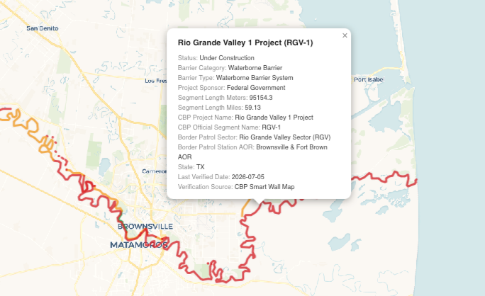
La cantidad de información disponible varía según el elemento y los datos que tengamos en ese momento. Trabajamos constantemente para ampliar y mejorar esta información. Si detecta que falta información en el mapa, escríbanos a wallwatch@theborderchronicle.com. ¡Gracias!
Consejos para explorar el mapa
· Active únicamente las capas que le interesen para reducir la saturación visual.
· Acerque la vista para obtener una mejor experiencia, especialmente en zonas con muchos elementos superpuestos.
· Combine varias capas para comprender mejor la relación entre la actividad de construcción y la infraestructura existente.
· Utilice los filtros Tipos de barreras para comparar las distintas formas de barreras físicas fronterizas.
· Haga clic sobre los elementos individuales para consultar información detallada y la documentación de respaldo.
