
Trump’s Border Wall Is Coming for Some of the Oldest Murals in North America
A $2.6 billion border barrier through Texas' Lower Pecos Canyonlands has archaeologists warning that irreplaceable indigenous rock art and sacred sites could be destroyed.
A $2.6 billion border barrier through Texas' Lower Pecos Canyonlands has archaeologists warning that irreplaceable indigenous rock art and sacred sites could be destroyed.
The efforts to preserve the desert's iconic plants, resist the destruction of ancient trees, and deal with the harassing border machine, even after deportation.

Long after they are deported, people are subjected to the Everywhere Border of surveillance, stigma, and economic hardship.
A $2.6 billion border barrier through Texas' Lower Pecos Canyonlands has archaeologists warning that irreplaceable indigenous rock art and sacred sites could be destroyed.

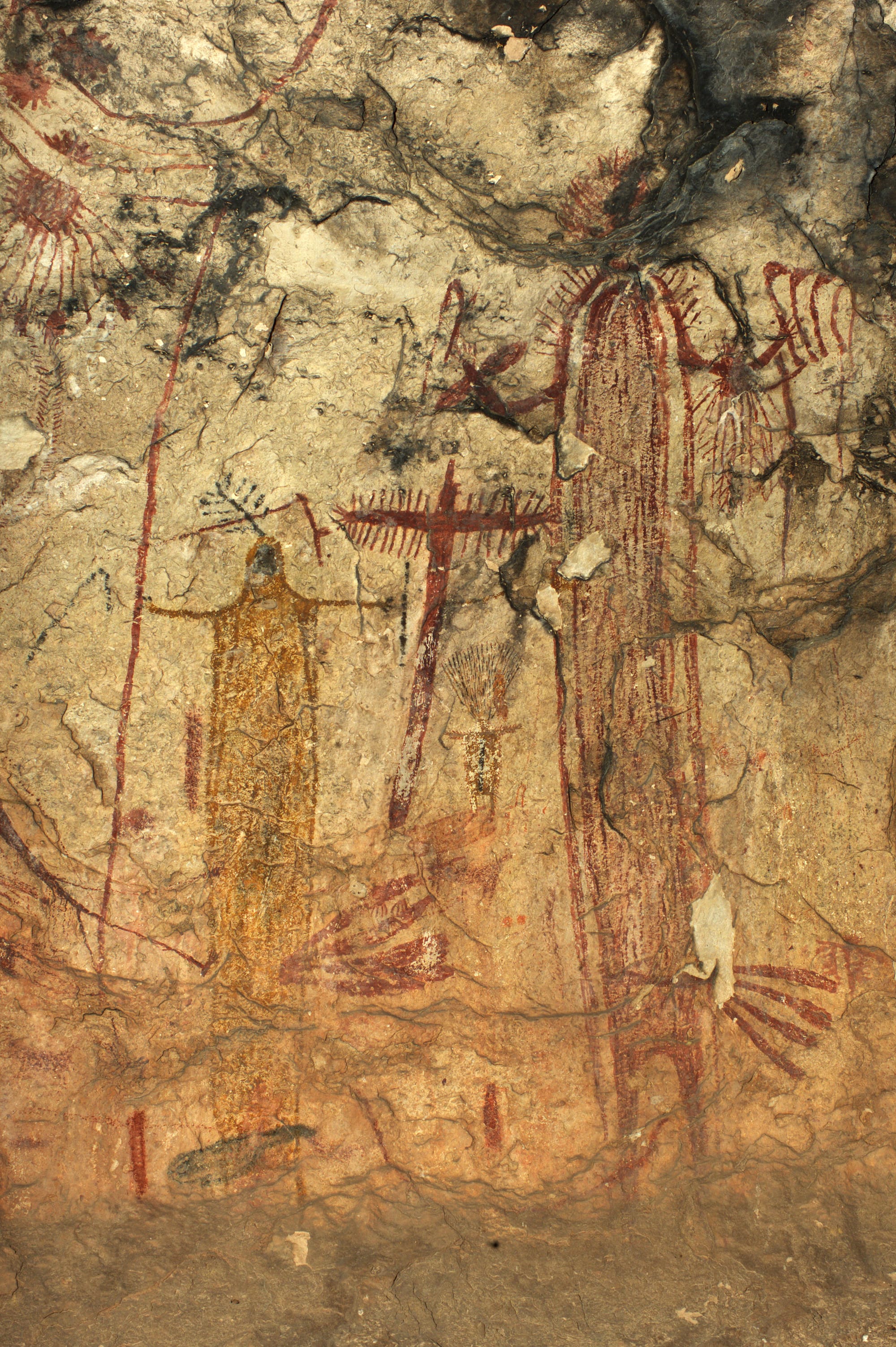
On June 3, the Department of Homeland Security awarded its largest upfront border wall contract to date to Fisher Sand & Gravel, a North Dakota company with a checkered past. The contract is for a barrier that runs the length of Val Verde County, Texas. Instead of building a traditional 30-foot steel border wall, the company’s $2.6 billion task is to cut a patrol road and erect what DHS describes as “low-profile vehicle barriers” through the rough limestone cliffs of the Lower Pecos region, where the Pecos River and the Rio Grande meet.
When Carolyn Boyd, a professor of anthropology at Texas State University, heard the news, she collapsed on the couch. Since that day, she said, “I’ve probably given myself brain damage from shaking my head so much.”
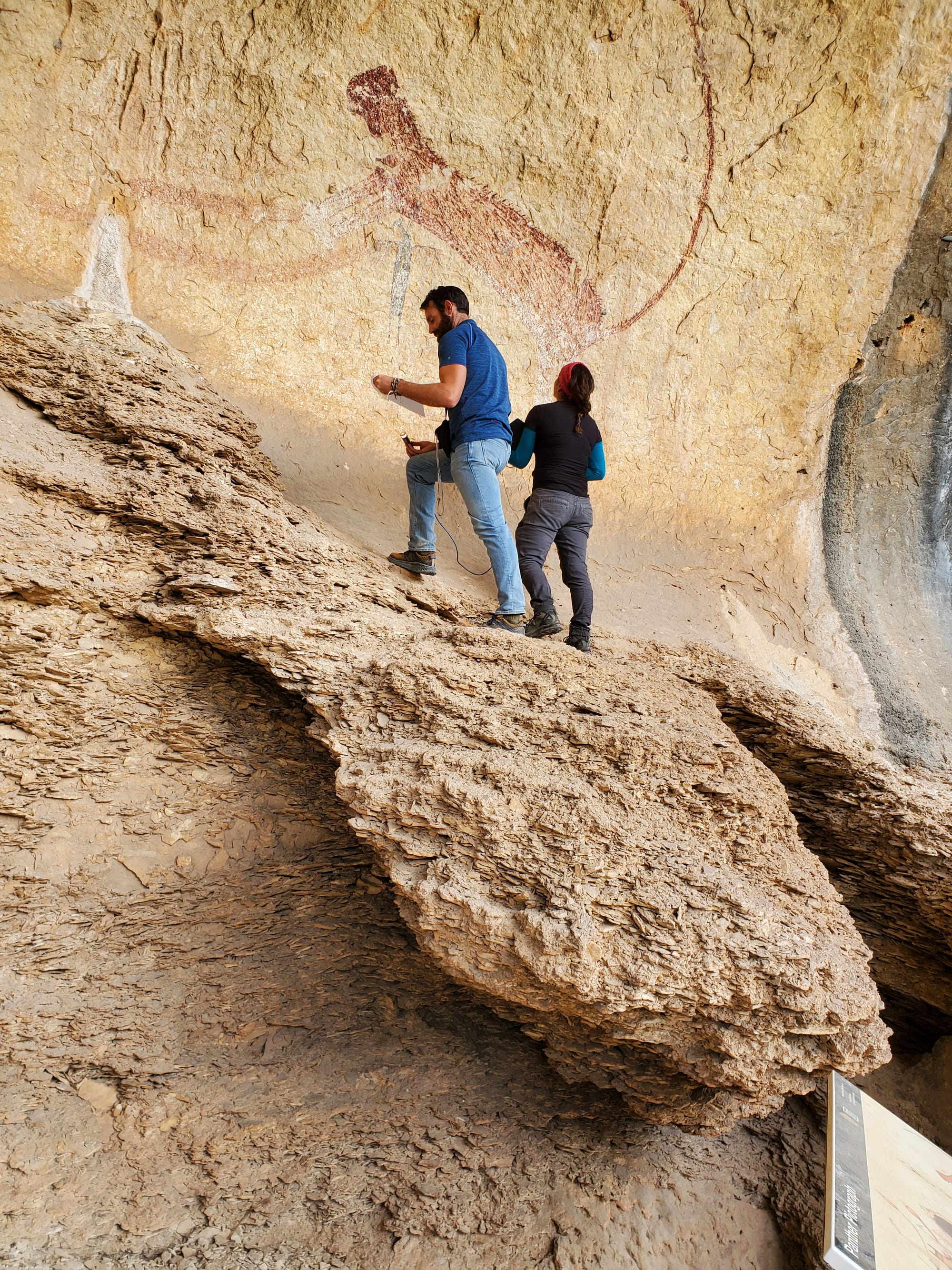
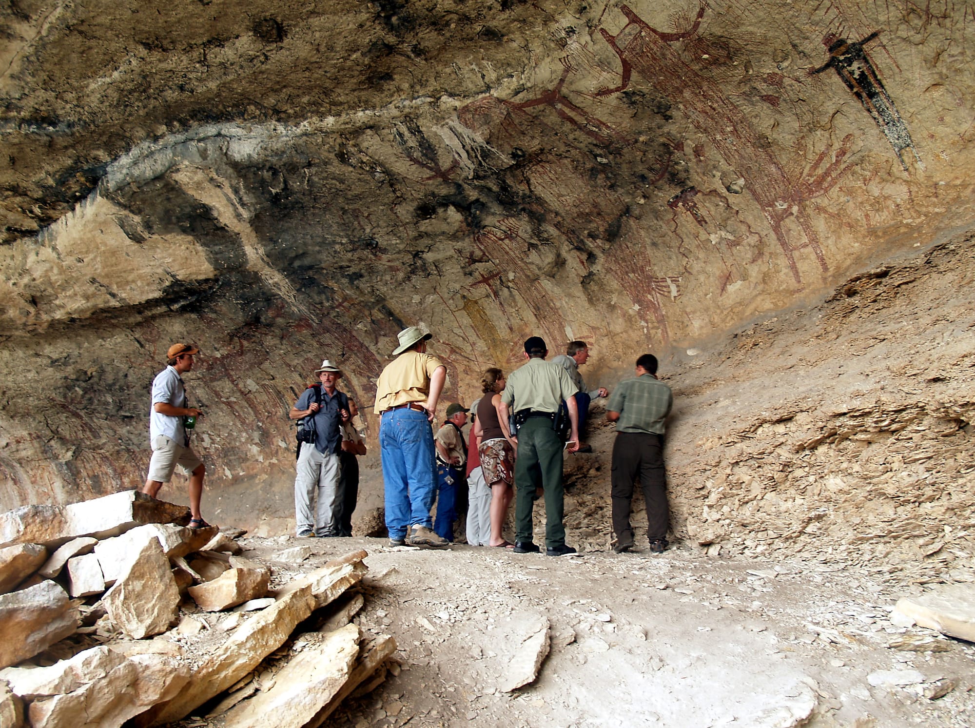
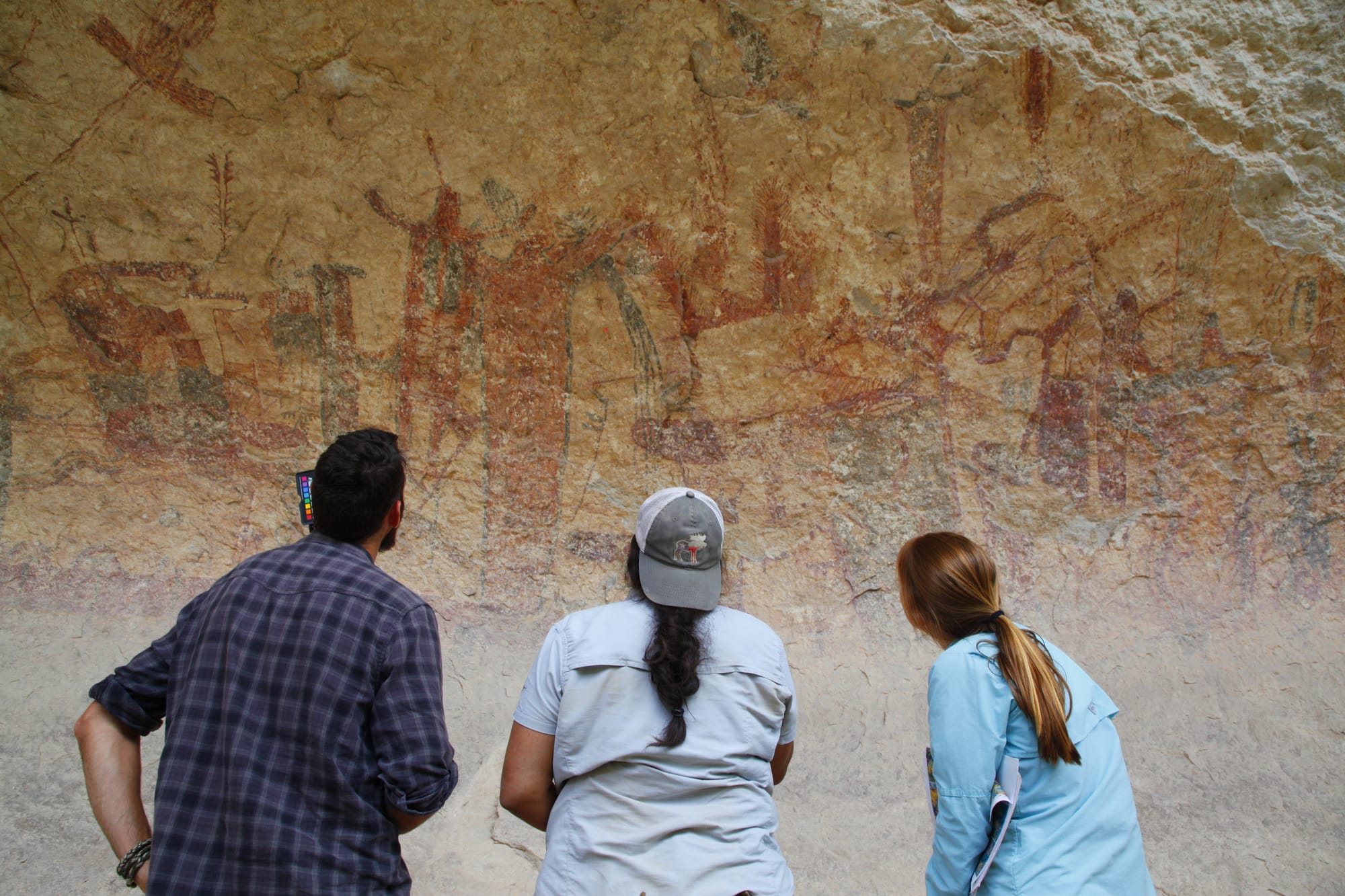
That’s because those limestone cliffs span the Lower Pecos Canyonlands Archaeological District, an 8,600-acre area with an unusually high concentration of hunter-gatherer sites, including over 300 known rock art installations, some dating back over 5,000 years. For almost four decades, Boyd has intensively cataloged and studied the murals of the Lower Pecos. Though she originally came to study these paintings as an artist herself, the work consumed her to the point that she is now one of the world’s leading authorities on rock art in the U.S.-Mexico borderlands.
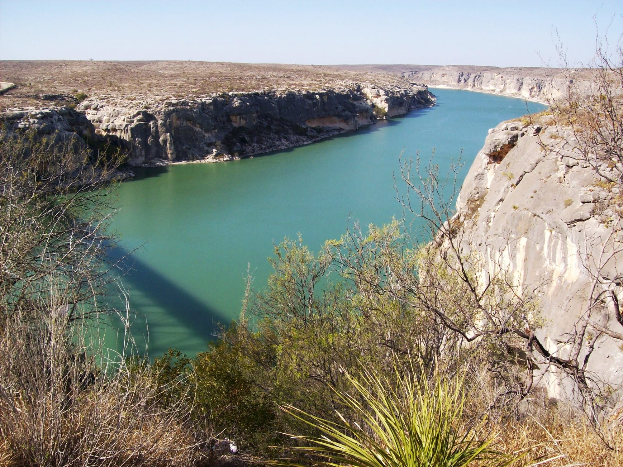
The Lower Pecos region is a scrubby savanna, a transition zone between the Texas Hill Country and the Big Bend. It is so sparsely populated now, and its climate so extreme, that it’s hard to believe nomadic bands of people once thrived in its caves and rock shelters, leaving behind a hardy material culture marked by items like hunting kits and lechuguilla-cord sandals. They also left behind an iconic artistic tradition: rock art murals hundreds of feet long, featuring a dizzying array of figures and designs that still feel alive thousands of years later.
Though the mid-1800s United States and Mexico boundary surveys made passing reference to the region’s rock art, but serious study and contemplation by Anglo-Americans didn’t pick up until the 1930s, when San Antonio’s Witte Museum embarked on a major effort to document the hunter-gatherer past of the Lower Pecos. Now, thanks to the border wall, that work may never be complete. Raymond Skiles—a retired National Park Service biologist whose grandfather worked for the Witte Museum—hopes the government is open to shifting its plans, though he isn’t optimistic. His family’s Val Verde County property is home to several important sites, including the Bonfire Shelter, North America’s oldest and southernmost “buffalo jump” site, a type of hunting technology commonly associated with groups on the Great Plains thousands of years later.
“There’s a long history of archaeologists in [this] area, but much of it still has not been documented,” he said, referring to the fact that very little of the Rio Grande corridor has been formally surveyed for cultural resources.
The barrier will also cut right through the local cemetery, meaning that crews could be dredging for fiber-optic cable and mounting stadium lights right through Skiles’s parents and grandparents. “I don’t think anyone is cognizant of what it’s going through,” said Skiles. “They’re thinking, ‘Oh, from Google Maps, it looks good.’”
The Big Bend Sentinel broke the story in January that even the most remote and least active parts of the border will get some kind of physical infrastructure. Since then, Amanda Castañeda, the archaeology director at Shumla—a nonprofit that Boyd helped found that is dedicated to preserving the rock art of the Lower Pecos—has been gearing up to help landowners document their sites in advance of potential construction. In April, researchers and Indigenous groups raised alarm after wall contractor BCCG bulldozed through a 1,000-year-old intaglio belonging to the Tohono O’odham tribe in Arizona. “It’s the canary in the coal mine,” Castañeda said. “This is what could potentially happen to sites all across West Texas.”
When Boyd started studying Lower Pecos murals in the 1980s, rock art was not considered a field of serious study. Conventional wisdom at the time, according to Boyd, was that no one should waste time trying to figure out what the panels “mean”—they were seen as the product of a culture so different from ours that trying to understand them was an exercise in futility.
Boyd had a sense that there was more to the story. She started applying anthropological research methods to gather data about how different historical groups in what is now the United States and Mexico understood their place in the universe and represented it through art. Focusing on the White Shaman—a mural near the confluence of the Pecos River and the Rio Grande—she conducted extensive research into cultures and cosmologies associated with the Uto-Aztecan language family, which spans Indigenous groups throughout the southwestern United States and Mexico.
Through that research, she saw similarities between the panels she was looking at in Texas and the codices produced by Mesoamerican civilizations, and built a groundbreaking theory: these paintings are more like our modern conception of a book than a painting you might put up to decorate your home. She wrote in 2016, “We now know that most are not a random collection of images painted over the course of time but rather compositionally intricate, highly patterned and rule-governed visual texts.”
Boyd’s research involved traveling to Mexico to meet with elders and spiritual practitioners representing the Huichol, also known as Wixárika, a group now mostly based in western Mexico but that has ancestral ties to the deserts of north-central Mexico. She made a long scroll rendering of the White Shaman mural, which she presented individually to gauge their reactions. Their consensus was that the painting tells the story of the creation of the sun. “They were reading paintings thousands of years old they’ve never been to,” she said. “Worlds changed for me at that point.”
Over the years, one of the elders, Matsuwa, traveled to Texas multiple times to visit these sites in person. He was visibly upset when Boyd told him that there were additional sites with paintings that had been flooded by the creation of the Amistad Dam in the 1960s. To Matsuwa, the paintings were living beings that had borne witness to hundreds of generations of human knowledge.
Matsuwa passed away last fall, and a part of Boyd is relieved he isn’t alive to learn that dozens more could be damaged by heavy equipment. “He would be beside himself,” she said. “If they come through with a bulldozer and do damage to one of these sites—from an Indigenous perspective, they’re attacking living beings, they’re attacking their ancestors.”
Now Boyd is wrestling with all the unknowns and the weight of not knowing what to do. The paintings are not of her ancestors, but she’s spent the greater part of her life thinking about them. “I feel responsible for them, and I feel so helpless to protect them,” she said.
Boyd said many people seem to be under the impression that if the federal government only knew about the importance of Lower Pecos archaeology, they’d agree not to build a wall. Yet these resources don’t seem to be matters of concern to them. Dozens of natural and cultural resource protection laws, as well as laws regulating government contracting, have been waived since October using laws passed during the Clinton and first Bush administrations that give the Secretary of the Department of Homeland Security—an unelected member of the president’s cabinet—the authority to waive any regulations necessary for the “expeditious construction of [border] barriers and roads.”
Use of these waivers has expanded rapidly during Trump’s second term. In May, the agency waived cultural resource laws for a stretch of Brewster, Terrell, and Val Verde Counties beginning in the rugged Lower Canyons and ending in an unnamed creek in Mexico just upstream of Langtry. On June 9, the agency realized its mistake and posted a revised waiver with coordinates that correspond to Big Bend Ranch State Park, Big Bend National Park, and the Black Gap Wildlife Management Area. It spares Shumla’s research area, at least for now. But that could change with the swipe of a pen.
Ending DHS’s ability to waive environmental and cultural laws would require repealing or amending the REAL ID Act, the 2005 law that broadened the agency’s powers to speed up wall construction. Boyd urged folks grappling with feelings of helplessness and responsibility like hers to make calls to elected officials and spread the word as much as possible.
“These are not just archaeological sites—they are part of a sacred landscape, they’re libraries of human knowledge,” she said. “They are the voices of 175 generations that lived in the region, and we are their voices now.”
Support independent news from the U.S.-Mexico border. Become a paid supporter of our work for $6 a month or $59 a year. Your subscription funds independent journalism!

As housing projects, mines, and border wall construction accelerate habitat loss, photographer Eliseu Cavalcante documents the Tucson Cactus and Succulent Society’s efforts to preserve the desert’s iconic plants.


Spanning a thousand years and multiple continents, the new novel Filth Eaters casts vampires as the world's ultimate stateless people.


This month, Hull’s worst fears came true as contractors for Southwest Valley Constructors and Kiewit started bulldozing and scraping land near her home to construct a 30-foot border wall.


Gabriela Rangel, executive director of Tucson’s Museum of Contemporary Art, was born and raised in Caracas, Venezuela. As a
Independent news, culture and context from the U.S.-Mexico border.